Hydrogeological map of Czechoslovakia 1 : 200,000 – territory of the CR (raster)


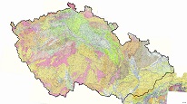
ArcGIS Server service for accessing the hydrogeological maps at a scale of 1 : 200,000 of the Czech Republic. This area contains 15 map sheets from the series of maps from the whole area of former Czechoslovakia. Web map service was made from the raster data.
služba
https://registry.geology.cz/id/NGMD_ARCH-HYDROCR200_R-SDE-SER
ESRI_MAP
CGS Geoscientific themes:
Spatial scope:
GEMET - INSPIRE themes, version 1.0:
 ISO 19119:
11.99,
48.253,
18.91,
51.247
vytvoření: 01.02.2012
Klárov 131/3,
Praha 1,
118 00,
Česká republika
tel: +420257089411
email:
metadata@geology.cz
Role: správce
Ing. Martin Paleček
Leitnerova 204/22,
Brno,
602 00,
Česká republika
tel: +420543429261
email:
martin.palecek@geology.cz
Role: kontaktní bod
Kvalita
Map series published between years 1980 and 1990 contains 28 map sheets.
WMS from the CGS raster data.
WMS from the CGS raster data.
Omezení
Informace o metadatovém záznamu
5adf1629-1f10-4c2d-9430-2c470a010852
Mgr. Pavla Kramolišová
Kostelní 364/26,
Praha 7,
170 00,
Česká republika
tel: +420 234 742 161
email:
pavla.kramolisova@geology.cz
Role: kontaktní bod
27.02.2026